More than a desk and a parking spot: Tapping into the Region’s Employment lands
Yesterday’s under-utilized industrial sites may be our communities of tomorrow, through a mix of housing, office, and retail development. But we are being held back by unhelpful rules and procedures that prevent us from using our land resources more effectively.
Today, we find ourselves at a time where we can optimize the benefits of transit investment. We have set forth the largest build-out in regional transit ever; we are back in the housing game with all three levels of government coming to the table; and, we are experiencing unprecedented regional population growth and intensification.
It’s time for us to re-learn from our past successes.
Fit for the Kings
In 1997, then Toronto Mayor Barbara Hall launched the “Kings” initiative in Toronto by ‘deregulating’—relaxing 1 Ken Greenberg is a visiting scholar and Vice- Chair of Ryerson CBI planning and zoning requirements—on 400 acres in two former industrial areas along King Street, east and west of downtown. In the past, King/Spadina and King/Parliament had served as manufacturing districts, but started their decades-long decline in the 1970s as manufacturing activity took new forms.
Prevailing zoning regulations had frozen the Kings as traditional, heavy-industrial areas, prohibiting most types of modern development. As the area declined, the City attempted to stimulate reinvestment for employment uses as vacancy rates increased and property owners replaced heritage buildings with parking lots to reduce realty taxes.
Through a consultation process that I participated in with a group that included Jane Jacobs, developer Robert Eisenberg, economist Gary Stamm, and Chief Planner Paul Bedford, traditional land use restrictions were removed and these districts were re-designated as "regeneration areas" to encourage reinvestment, create housing opportunities and offer new business spaces.
During the 20 years that followed, over 50,000 housing units have been built in the Kings along with millions of square feet of commercial space, often within former industrial buildings and increasingly in new buildings. Employment activity in both regeneration areas has increased dramatically by 18 per cent since 1996, outpacing the city-wide growth rate of 11 per cent. Nowadays more people are currently working in the Kings than during the height of the industrial era. The development changes increased total taxable assessment by over 28 per cent (approximately $400 million) in the two areas between 1998 and 2002.


Building complete communities
In 2017, we now have a similar opportunity to make a positive impact on the city by relaxing counterproductive policies that prohibit mixed-use in communities experiencing transit investment. The primary driver for this change is a convenient lifestyle for employees and employers who seek walkability and integration of local amenities.
Even suburbs are rethinking the importance of mixed-use development. Suburban workers want more than a desk and a place to park. They want access to retail, recreation, child care amenities, places to grab lunch, and still be close to home to check in with family.
Unfortunately, our provincial and municipal policy frameworks have not caught up with the changing nature of work and the value of mixed use. In fact, there is a striking contradiction in the provincial “Places to Grow 2017” Growth Plan which prohibits this kind of integration at many of the existing and proposed GO transit stations and the proposed regional express rail (RER) network.
With at least half of provincial regional transit plan budget dedicated to RER— upgrading the service and adding some stations to existing GO lines—equal ambition should be paid to upgrading the GO stations and catalyzing mixed-use, mixed-income developments around these stations. Instead of building more parking spaces, there is a chance to unlock the potential for more housing and provide opportunities to live within walking or cycling distance to transit.

New parking lots at Erindale GO Station.
(Metrolinx)
From parking lots to communities
On the one hand, Section 1.2.1 of the Growth Plan guides “how land is developed, resources are managed and protected”. Public dollars are invested based on integrating principles such as: “the achievement of complete communities that are designed to support healthy and active living and meet people’s needs for daily living throughout an entire lifetime, prioritize intensification and higher densities to make efficient use of land and infrastructure and support transit viability.... and support a range and mix of housing options, including second units and affordable housing, to serve all sizes, incomes, and ages of households”. Meanwhile, in the same document, Section 2.2.5 isolates ‘Employment’ as a standalone category and makes no mention of mixed use as key driver of contemporary life combining living and working in the same locations. In fact, it largely reverts to an earlier view of segregated land use planning through protected ‘Employment Lands’ that specifically prohibit mixed-use: “Municipalities will plan for all employment areas within settlement areas, with the exception of any prime employment areas, by: a) prohibiting residential uses and limiting other sensitive land uses that are not ancillary to the primary employment use”.
While there is undoubtedly a need to “provide certainty for traditional industries, including resource-based sectors”, the reality is that most forms of contemporary employment thrive in integrated mixed-use communities. This problem is compounded by the fact that many of these designated ‘Employment Lands’ are former industrial and warehousing sites that hug the railways and were served by former rail sidings where the transit stations are located.
By protecting the areas surrounding GO commuter stations for traditional forms of employment, new types are discouraged, resulting in doubly painful opportunity costs. There is now very little need or desire to build the standalone office parks of previous eras, and the opportunity to build thousands of housing units throughout the region in desirable locations is forgone. The default is often warehouse and logistics buildings that provide very few jobs in valuable locations which will increasingly be served by all day GO and RER transit service with more frequent but poorly utilized service.


A helpful way to visualize this disconnect between the Growth Plan and the GTHA Regional
Transportation Plan is with the online interactive Geoweb Map created by the Neptis Foundation.
By superimposing the layers for ‘Employment Lands’ and ‘existing and proposed transit stations’
the problem is clearly revealed.
Mixing it up
Zeroing in on a couple of examples makes it even more obvious. The 60- acre Unilever site at the mouth of the Don River and a major gateway to the Port Lands is a candidate for a major transit nexus with a new RER station and an extension of Light Rail linking Riverdale to the waterfront. It is also slated for redevelopment. But this former industrial site is designated as Employment Lands which prohibits mixed use. Current plans reflect this prohibition, and call for one of the largest redevelopment projects in the region with over 11 million square feet of office space and zero residents.
The closest international parallels were recently presented at an Urban Land Institute gathering on Global Business Hubs at the same Unilever site. Canary Wharf in London and Hudson Yards in Manhattan are intensively mixed use, and combine living and working space. The contrast is striking.
In fact, the Unilever site may replicate the conditions Toronto experienced two generations ago when the major bank towers where being constructed at King and Bay. At the time, the area was conceived as a monolithic CBD (Central Business District). The homogeneous sterility of this area, threatening to expand and empty after 5pm, led the City of Toronto to create a new Central Area Plan which brought residential use into the core. This made-in-Toronto pioneering mixed-use policy initiative (combined with the Kings) brought in 240,000 residents, and the population is expected to double by 2041. The vast majority of these downtown residents get to work by walking, cycling, and using transit.

Employment Lands designation on the Unilever site.

A recent image of an all-office development on the 60-acre Unilever site recreating the single-use
conditions King and Bay in the 1960s.
Moving away from mixed use in the Port Lands?
There has recently been excellent news about the approval of tri-level funding for the flood-proofing of the Lower Don after many years of study and preparation. This has opened exciting possibilities for the development of the Port Lands as the city’s next great urban frontier (among other things to be well served by light rail transit). Unfortunately, with the “Proposed Land Use Directions, Port Lands Planning Framework” now before City Council, it may fall into this same trap backtracking from the previously recommended Regeneration (mixed-use) designation.
Many Torontonians were hoping for a more forward-looking 21st century ‘innovation district’, served by new light rail transit and active transportation. A contemporary environment would skillfully combine mixed-income housing with creative uses including film production, community amenities, employment, and retail along with a large dose of public space and parkland along the harbour and the Shipping Channel. Former Toronto mayor David Crombie originally conceived the waterfront as being clean, green, and accessible to all, with enough density and diversity to produce great new waterfront neighbourhoods.
This was the vision put forward by Waterfront Toronto to attract progressive local and international developers. This was the vision that Torontonians bought into. We were starting to see it come to fruition in the plans for Villiers Island, and the Lower Don parks and river relocation. However, what we are now seeing for the rest of the Port Lands (an area almost as large as downtown Toronto) is a reversion to a somewhat conventional segregated coarse-grained and old-fashioned land use plan. The suburban tendency to over-specify single land use categories and stifle innovation and creativity has crept back in.

This new Framework may waste this excellent opportunity to help Toronto create something unique in the world. The Port Lands shouldn’t end up as a giant industrial park. It doesn’t make sense to spend over a billion dollars to create a vast new urban area by the lake, and then encourage buildings that don’t benefit from being near the water.
One thing that the 400 or so participants in the recent Waterfront For All Summit 2 agreed upon, is that Toronto’s Waterfront should benefit as many people as possible, whether they are visiting, living, or working. There should be diverse neighbourhoods which include social housing. Development by the lake should allow people to enjoy the views and experiences that are possible next to the water. Access to and enjoyment of the lake should benefit everyone, enriching our city as a whole.

While Chicago goes in the opposite direction on its equivalent great strategic land reserve
While Toronto moves backward to segregated land uses, Chicago is rethinking its Employment Lands issue 3 where they are known as PMDs (Planned Manufacturing Districts). Mayor Rahm Emanuel has stated “Chicago’s industrial policies have been focused on the rear-view mirror for too long. These improvements are designed around the future, especially the mixed- use business districts that attract and support the jobs of tomorrow.” The plans call for the re-zoning of the northern and southern portions of the 760-acre North Branch Corridor to accommodate mixed-use development including residential.
New designations4 enable a dynamic mix of uses previously prohibited by Planned Manufacturing District (PMD) zoning. However, the new designations will also cost developers a fee and a potential density bonus as well, with revenues directed to transit, public space, and other public realm improvements. This fee structure could be applied to re- designation in the City of Toronto to guard against underpaying for under- zoned employment/industrial lands, which may dissuade development in costlier locations such as much-needed midrise on our avenues that are already zoned for residential.
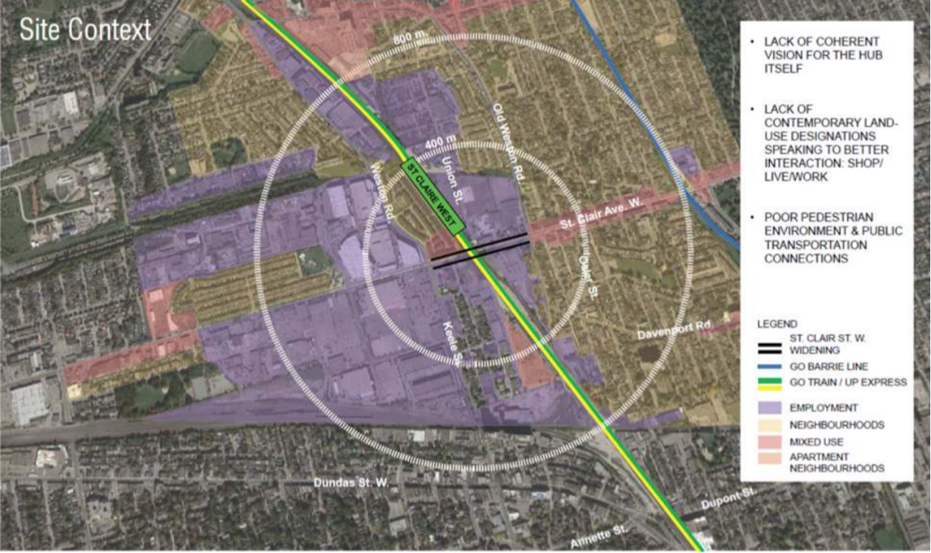
A more typical example of the conundrum in the GTHA can be found at St. Clair and Weston Road where a new RER station is being created interfacing with Light Rail. Once more, for historic reasons relating to former industrial use, the majority of the lands surrounding the ‘transit hub’ are designated Employment Lands. And once more, mixed use is largely prohibited despite landowners who would like to combine forces to leverage the transit investment with a combination of living and working in a compact transit-oriented walk-in form.
The frequent claim that a province-wide one-size-fits-all ‘Employment Lands’ policy is necessary to prevent encroachment by residential development is vastly overblown. It ignores the obvious need to distinguish among different employment situations and acknowledge that most employment is attracted to mixed-use areas. It also fails to recognize that we have the regulatory tools to achieve a desired balance of uses as we demonstrated in the past with the Central Area Plan and in other situations where the market required some guidance.
Another rationale advanced for preventing mixed use is that releasing relatively cheap commercially zoned lands to include housing may reduce pressure on the market to build out the ‘avenues’ with missing middle density. With the staggering growth we have to accommodate in Toronto, development along these arteries will continue. Eglinton Avenue in Scarborough is attracting serious developer interest along the proposed LRT.
This argument also doesn’t address the poorly used investment in transit infrastructure throughout the region that curtails the ability to generate vastly greater amounts of both housing and jobs in many strategic locations. These goals are not mutually exclusive. The real opportunity is to reduce pressure on greenfield sites by giving people a greater range of affordable places to live that are not car dependent.
We have mechanisms that could ensure a mix (i.e. residential permissions dependent on achieving a certain amount of employment-related uses first and examples where these have been used). The cost for not availing ourselves of the opportunity to revisit this policy and use these tools is simply too high.
Yet another unintended and self- defeating by-product may be that given recent trends, especially the concentration of office development in just a few central locations, many sites outside the core could end up residential-only because the available absorption is corralled into centrally located Employment Lands. This would diminish the opportunities to take advantage of reverse commuting and all- day service to locations beyond the core, and undermine mixed office/residential outside of downtown Toronto.
A stock response to this issue is sometimes that municipalities can already re-designate Employment Lands at the time of a five-year Municipal Comprehensive Review. This process is onerous, has uncertain outcomes, and comes with a high level of resistance. This especially applies to lands surrounding or near transit stations where there is clear need for a better policy solution that goes beyond the current MCR process and requires the identification of those cases in which re- designation is a priori appropriate.
The need to reconsider segregated land use policies is particularly acute for the successful development of suburban areas. The Director of Finance for the Town of Milton has just released a report entitled “Town of Milton Long-Term Fiscal Impact Assessment of Growth 2017 to 2036” prepared by Watson & Associates Economists Ltd. It provides a Fiscal Impact Assessment for the Sustainable Halton Lands including potential mitigation strategies that would reduce the forecasted pressure on both the Town’s projected tax rate and debt capacity. The assessment identifies several areas for further review including focusing on non-residential growth, supporting mixed-use growth in the Agerton Employment Area and reviewing the service delivery model for transit. Similarly, it is recommended that the Trafalgar/Derry Lands should be considered a prime opportunity to create a mixed-use node that is inclusive of employment uses. The locational attributes of the Trafalgar/Derry Lands and their connection to a potential GO station is seen as supporting the development of such a concept. It is suggested that existing and planned assets that characterize this area can be used to foster economic advantages and attract a range of knowledge-based employment sectors, including a growing office market. One of its conclusions is that if the Agerton Employment Secondary Plan area was developed as mixed use, an additional 15,165 people could potentially be accommodated.
Procurement that allows for collaborative place making \A related self-imposed impediment to integrated transit-oriented development has to do with the way Metrolinx and Infrastructure Ontario procure bidders for transit lines and stations entering into contracts for the private sector to finance, design, build, and operate these facilities. With the intention of mitigating cost overruns and passing the financial risk on to the private sector, the system requires carefully defined project delineation with clear self-contained and inviolable contract limits. These barriers have the unfortunate and perhaps unintended consequence of making it difficult to fully integrate stations with surrounding development or leverage opportunities for stations to be built as part of the development itself. Yet decades ago we integrated development within our subway stations, for example those on the downtown loop of the Yonge/University subway line.
Conceptual ‘scope creep’ in the form integrated place-making is paradoxically exactly what is desirable in city building terms. We must find ways to manage procurement that anticipates and fosters such overlap while controlling costs.
Integrating the public realm
An integrated approach to procurement should be extended from buildings to the public realm, and the treatment of the rights-of-way transforming the streetscape, strategic design, and program interventions at key nodes to create multi-service ‘community hubs’. It should also encourage green connections that engage various stakeholders, including local communities.
These critical, but often neglected public realm investments, can leverage the public return on investment by enhancing conditions for job creation and housing with more intensive use of strategic lands and increased tax revenues. If we overcome these dual barriers of land use policies which prevent mixed use and procurement policies which frustrate collaborative development, an enormous potential is released to use our land resources more effectively.
Getting mixed use “on track”
On November 22, 2017, the Ryerson City Building Institute hosted a panel event 5 exploring collaborative models to achieve transit oriented development in the GTHA. Speaker Tom Clark from Denver, former CEO of Metro Denver Economic Development Corporation, explained how his city advanced transit oriented development promoting vibrant, sustainable communities with a diverse mix of land uses at various densities within a 10-minute walk, or about a half- mile, of all its 59 light rail transit stations through the requirement for ‘Station Area Plans’. These plans bring most activities of daily living within walking distance of the station, and encourage a mix of land uses, improved streets, and streetscapes to increase mobility choice and walkable and bikeable connectivity. They encourage reinvestment and redevelopment of industrial areas while maintaining and creating diverse employment opportunities.
They are also good business. One of the other speakers at the event, Robert Yaro, past President of the Regional Plan Association of New York, made several recommendations to promote transit- oriented development in districts surrounding station areas. He advocated developing plans, zoning, and establishing other regulations specifically designed to promote walkable, transit- oriented, mixed-use districts with a 3 to 5 km radius of transit stations.
He further argued that these should be designed to promote land value uplift / value capture techniques that would help fund transit investment. Transit service improvements and capital investments should be targeted to communities that adopt these transit-oriented development uplift and value capture strategies. In the case of the GTHA, Metrolinx should also require that communities compete for new transit stops and services by committing to these TOD / value capture plans and regulations.
Yaro advocated the potential for joint development curated by Metrolinx at station areas to transform surface and structured parking areas at stations into high-density, mixed-use development sites in partnership with private developers, with value created to be shared by Metrolinx and developers. Metrolinx could dedicate the proceeds to help finance its capital program.
We have myriad opportunities in the GTHA to do this as we move to the next round of hard-won investment in our expanded transit network. It’s time to stop artificially holding ourselves back through self-imposed policy restrictions. We must get on with adding needed housing and job opportunities well- served by transit throughout the region in the right places by allowing employment to go where it increasingly wants to go: in mixed-use settings distributed throughout our rapidly growing multi-centred region. Jobs of the future are more than a desk or a workspace and a parking spot. They are part of a community.